 |
The Kirghize flag,
a stylized yourta |
Human geography
Physical geography
Human geography
- Population: 4 921 000
- Capital: Bichkek
- Languages: kirghize, Russian
- Religion: Islam, minority the orthodoxe ones
- Nature of the State: unit republic
- Head of the State: Askar Akaiev
- Prime Minister: Koubanytchbek
Djoumaliev
- Head of the government: Kurmanbek Salievich
Bakiev
- UTC: +5 hours
- Currency: Soum
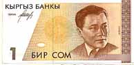 |
1 soum
click! |
|
return
The Flag

The flag is a red field with a yellow sun in its center; the 40 rays of the sun represent the 40 Kirghizes tribes. With the recto, the rays are tilted in the direction reverses needles of a watch, with the back in the other direction. In the center of the sun, in a red ring, two sets of three lines cross, representative, in a stylized way, a traditional yourte Kirghize.
return
Emblème
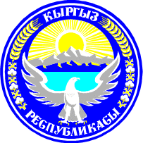
National emblem of Kirghistan.
return
Nooruz

Kyrghyz people call the first day of the asian year "Nooruz" and eat a speacial recipe called « Nooruz köcö ».

return
Majors events
- 1st january: New Year's Day
- 7 january: Christmas (Orthodox Church)
- 19 january: Orozo Ait
- 8 march: Woman International Day
- 21 march: Nooruz
- 27 april: Kurban Ait
- 1st may: International Day of Labour
- 5 may: Constitution Day
- 9 may: Victory Day
- 31 august: Independance Day
return
Physical geography
Kirghizie extends on 198 500 km². 94 % of the country are good mountain with an average altitude of 2750 m.
Single: 40 % of the territory are above 3000 m, including 3/4 pennies of the eternal snow and the glaciers. Thehighest mountains are in Tien Chan, with the spectacular chain of Kokshal-Tau which marks the border with China. Gold medal-holder: the peak Pobedy (Russian Victoire!) with 7439 m.
The barrier of Fergana and Pamir Alay in the South take the valley of Fergana out of scissors. The peak Lénine dominates Pamir top of its 7134 m the paradise of the mountaineers and of in love with beautiful excursions.
The capital, Bichkek, are located in the lowest zone, that is to say to 800 m of altitude.
 |
| Relief map |
|
 |
| Territorial Card |
|
For those which do not like the mountain, all is not lost. The lake Issyk-Koul, located at 1600m of altitude, gigantic (180 km length, 58 km with broadest, 700 m with deepest) never freezes and turns around 20-22°C in summer (bathe without obligatory moderation).
This true inland sea is slightly salted. One of the jewels remains Song Koul, lake of altitude, which can ravir the few tourists. Many other lakes of altitude and powerful frozen rivers will be able to delight the hikers. To also note, the large tank of Toktogoul and its hydroelectric stopping (the only one of the country!).
You can also consult other cards produced by the C.I.A.
return
Tash Rabat
It's the most important building in stone in Central Asia. Near Torugart, at 3900 meters high, it is a bridge between Central Asia and China. It was a very popular way for Silk Road merchants, and for the Gengis Khan warriors.


return
|


)
)
)
)
)
)
)
)
)
)